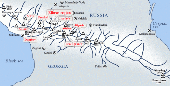
The Caucasus Mountains
is a huge mountain range, considered to be a boundary between Europe and Asia. The Caucasian ridge extends for 1200 km from the East to the West, from the Black Sea to the Caspian Sea. 5 countries are situated here - Georgia, Armenia, Azerbaijan, Turkey and Russia. All the territory situated to the North of the main Caucasian ridge belongs to Russia and it is named the Northern Caucasus.
The North Caucasus is not only well known Mt.Elbrus, 5642m, (the highest Europe Top). It is more than 1000 km long Main Chain with well developed mountain country. Unfortunately, now it is practically unknown country for foreign tourists and investigators, it has to be rediscovered again. More than a century ago it was discovered by Merzbacher, Freshfield, Vitorio Sella. But after October revolution the country was almost closed for visiting. Only some climbers and tourists were there. Now we try to change this situation and show our guests not only Mt.Elbrus, a “must be” point for many climbers (as one of the Seven Summits, the highest peak of Europe). We would like to make them acquainted with the whole region.
The Northern (Russian) Caucasus is divided into 3 parts: West (from the Black See to Elbrus), Central (between Elbrus and Kazbek mount 5033m) and East (from Kazbek to the Caspian See).
The West Caucasus is Mt Elbrus its West slope and then some (ab.20) valleys to the Black See, Sochi city, (Krasnaia Poliana, XXII Winter Olympic Games 2014 capital). The main valleys from Elbrus are: Ullukam river (Uzunkol region); Teberda (Dombay); Zelenchuk (Arhyz, Aksaut, Marukha); and others .
|
Arhyz
region was one of the most popular places on the Caucasus in the Soviet time. The Arhyz village 1450m is on a confluence of 4 valleys with uncounted summits and passes. The mountains, a good stable weather (at the region there is the biggest Russian mirrow teleskope, because of most number of clear ski days!), long summer period and a certain snow condition from November till May give good opportunity for trekking, climbing and ski-touring.
Arhyz was an important part of the Great Silk Road. Close to the village there is an ancient town with oldest (IX sc) Christian cherch in Russia. During the trek it is possible to see some other remains of the Silk Road.
See extra:
Arhyz ski tour gallery
Arhyz trek gallery
Arhyz ski tour video
|
Dombai
1650m ski station - one of the best in Russia, with 9 (totaly 16) ski lifts, hotels, restaurants etc. Inspite of the ski station on Mussachery massif 3150m (lifts to 3012m), the mountains around were never touched with ski touring, only the last 2 years we are skiing here actively. Peaks and passes for skiing are of 3000m to 3800m, good snow conditions from the beginning of November (2007 from Nov.10 more than 2 meters of snow!). Good choice of the slopes. One-two days it is possible to do a lift/off pist ski - North slope of Mussachery with powder is completely off pists and without a lift and any ski track!
See extra:
Dombai ski-tour gallery
Dombai trek gallery
Arhyz Dombai discovery trek video
Dombai ski-tour video
|
Aksaut
Almost unknown even for Russians, because there was a tungsten mine here and the valley was almost closed for visiting. Now mine is out, destroyed, but there is a road (higher it is a path) almost to the main chain. At the end of the road there is Aksaut Camp 2000m (some small huts-cabins with fire heater, sauna, generator). There are very beautiful mountains around good for skiing. (once we used the road, it is extremely hard for a car and for a group, for other visits we traversed over the passes from / to Dombay).
See extra:
Aksaut ski-tour gallery
Aksaut trek gallery
Aksaut ski-tour video
|
Uzunkol
Great faces of Dallar or Kirpich peaks attract your regard. At the beautiful valleys to approach there is a couple of ancient style of herdcabins, where you will be presented with local, here made cheese and airan (kefir). A car path goes to Uzunkol Mountaineering Camp (refuges for climbers), and a climber comes up to Dolomite peak or pass will appreciate of the closest view of the great West Face of Elbrus.
See extra:
Uzunkol trek gallery
|
Elbrus region
is Mt.Elbrus (with Azau and Cheget ski stations) and about 10 main valleys. The most popular from them among Russian climbers are: Baksan (Adyrsu, Adylsu), Chegem, Bezenghi, Digoria, Tsey (Tsey ski station).
Mt.Elbrus is of two tops: the West is the highest top of 5642m and the East top is of 5621m. Today the usual way for climbing is from the South. It is by car from Terskol village to Azau ski station 2440m, then with ski lifts to Garabashi = Barrels huts 3700m. From there, using a snowcat to Pastukhov Rock 4650m, you climb higher with crampons to the top.
The route from the North is the way of the first ascent to the East top of Elbrus July 22, 1829. Till now it is a wild place, no village and habitants, no hotel and lift, a trip there is more as an expedition. By car from the last city, Kislovodsk, you arrive to the tent Base Camp at Hatkhansu (silver spring) Meadow 2300m. Then by foot to Uncle Nick Hut 3760m and higher the Hut a you climb along the glacier slope to the top. All the way from Kislovodsk, Elbrus is well visible permanently.
The ways from East and West are less usual to climb. From East the way goes to the East top from Baksan valley, Elbrus village along the Irik valley. From West, it is the shortest way to the highest West top, close to the hardest Caucasus Face – Kukurtliu. Good reason is to do an acclimatisation program at Uzunkol region.
One of the very interesting solutions for skiing is a traverse from the South to the North. The ascent to the top from the South is easier and descent to the North is much more skiable.
See extra:
Elbrus region gallery
Elbrus from the North gallery
Elbrus race video
|
AdyrSu valley
is one of the best places for ski touring and acclimatisation program before Elbrus climbing. The valley is well isolated and no village and habitants, only Djailyk and Ullutau Mountaineering Camp (refuge) is at 2350m. Ullutau MC is 12 km from the Baksan valley and the closest village Verkhni Baksan. Entrance to the valley is a car lift of 60m denivilation (there is no other way), and the valley is visited only by herdsmen, climbers and ski tourists. Around there is a lot of peaks and passes with nice slopes and good and long snow condition. Peaks and passes altitude is from 3400m to 4100m.
See extra:
AdyrSu gallery
|
AdylSu valley
was one of the most popular climbing region in the Soviet time. And now there are 4 mountaineering camps there. The valley is a neighbors of AdyrSu and it is possible to passover Gumachi, Koiavgan or AdylSu passes.
See extra:
AdylSu gallery
|
Chegem
– neighboring valley eastwards from Baksan. It begins from the nice gorge of Chegem waterfalls. In the villages there are many ancient remains of Alan culture as towers and tumulus. 12 km higher the last village, Bulungu, there are two Mountaineering Camps (refuges) 2000m. Tikhtengen Peak, Thuiber pass were visited Vitorio Sella 1889 and 1896 and we can see the first photos of the Caucasus regions.
|
Bezenghi
is a great region of the Caucasus with the highest alpine peaks, 5 massifs higher 5000m! (Dykhtau 5203m, Koshtantau5145m, Djangitau 5085m, Shkhara 5068m and Mijirgi 5025m) the longest glacier of the Caucasus, great Bezenghi Wall. We call it as Caucasian Hymalaya – nice for trekking and extreme climbing. On the meeting Bezenghi and Kundum-Mijirghi valleys, at the end of Bezenghi glacier there is a Bezenghi Mountaineering Camp (refuges) 2200m. For a ski touring the region is of a bit long distances and of big denivilations but for strong skiers it is an impression place.
See extra:
Bezengi gallery
|
Digoria
is a big mountain country of 7 confluent valleys with one of the biggest glacier zone of the whole Caucasus, Karaugom plateau and glacier (Elbrus and Bezenghi area comparable). There is a lot of historical monuments of Alan epoch. Good option of beautifull mouts and well developped net of valleys gave big chose of ski tours, trekking, and climbing itinerarys. There are two Mountaineering Camps (refuge) at 1900m.
|
East Caucasus
is not very interesting for skiing because of much more continental climate and high snow/glacier line. For example, the West Caucasus glaciers descent to the height of 2500m, but East ones do it to 3500m! (This part is much more interestingt for climbing programs as Yarydag 3925m – Lime stone Face of 1000m vertical with the top plateau covered of ancient ocean shell remains on!).
Regarding the seasons: the Central Caucasus (higher and closer to Elbrus), ski season begins from mid of February (earlier it is cold and the snow is not formed well yet because of the coldness) and continues till the end of May. The ski season on the West Caucasus begins from mid of November and continues to the first part of May. Attention for Elbrus – before beginning of April it is not good to attenpt to climb from South because of a big part of ice slope around Pastukhov rocks 4650m (from 4400m to 5000m) and its hard glass (glazy) condition – cold. The first snow is gluing on the slope with the first warm wind (feune), arriving ab. April 5 to10. Till mid June the snow condition is OK for ski, only later the snow level begins to go up from Azau station and after ski descent longer and longer you have to go by foot or use the lift from Stary Krugozor 3000m to descent lowest part.
|

;)
;)
;)
;)
;)
;)
;)
;)
;)
;)
;)
